February 21, 2020
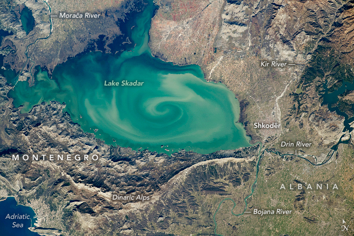
Dark and light sediments swirl around in the center of Lake Skadar, the largest lake on the Balkan Peninsula. This pattern captured the attention of an astronaut onboard the International Space Station (ISS).
Lake Skadar is a karst lake that straddles the border of Montenegro and Albania. It is an example of a cryptodepression, where parts of the lakebed extend below sea level. The curved, spine-like ridges running parallel with the southern shore are part of the Dinaric Alps, which are comprised mostly of easily erodible rocks such as limestone, dolomite, and other carbonates.
The swirling plume in the center of the lake is likely the mixing of sediment that has been transported downstream from higher elevations via snow-melt water and other mountain runoff. A major source of this sediment inflow comes from the Moraca River; its wide delta occupies much of the Montenegro shoreline. Smaller river deltas along the northern edges of the lake also contribute sediment. The Drin River and the Bojana River converge just south of the ancient lake-front city of Shkodër, which lies on the small delta of the Kir River. The lake and these rivers all ultimately drain into the Adriatic Sea.
As with many large freshwater lakes near cities, many of the native plants and animals in Lake Skadar became endangered due to human activity. Montenegro has since made the western portion of the lake a national park, and Albania declared its section as a nature reserve. Both efforts were made to protect many species of birds, microorganisms, and aquatic life, including eels, snails, and endemic fish species.
Astronaut photograph ISS062-E-40353 was acquired on February 21, 2020, with a Nikon D5 digital camera using a 400 millimeter lens and is provided by the ISS Crew Earth Observations Facility and the Earth Science and Remote Sensing Unit, Johnson Space Center. The image was taken by a member of the Expedition 62 crew. The image has been cropped and enhanced to improve contrast, and lens artifacts have been removed. The International Space Station Program supports the laboratory as part of the ISS National Lab to help astronauts take pictures of Earth that will be of the greatest value to scientists and the public, and to make those images freely available on the Internet. Additional images taken by astronauts and cosmonauts can be viewed at the NASA/JSC Gateway to Astronaut Photography of Earth. Caption by Sara Schmidt, GeoControl Systems, JETS Contract at NASA-JSC.
No comments:
Post a Comment